AltZero Studio
The Geometry of Sunlight
Made Visible
Architect-designed sun path and solar altitude diagrams exploring daylight across Earth — available as museum quality fine art prints
The Diagrams
Have you ever wondered...
...why the midnight sun exists?...why golden hour lasts longer in some places than others?...why the tropics and the poles experience sunlight so differently?
Altzero Studio presents two series of diagrams that answer these questions:Sun Paths Across Earth, and
Daylight Variation Across EarthBoth series map the geometry of sunlight across our planet precisely and completely, revealing the surprisingly beautiful patterns that govern the Sun's light on Earth.
01. Sun Paths Across Earth
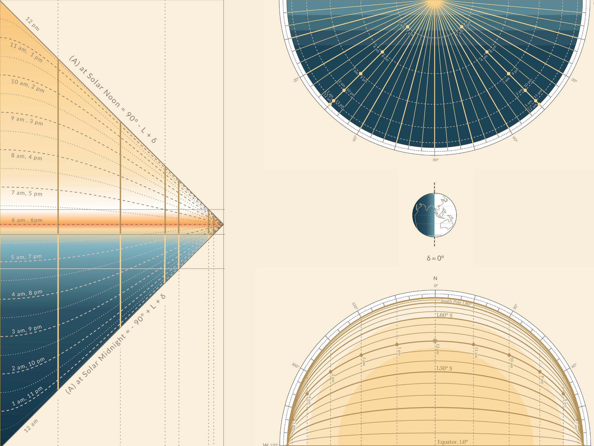
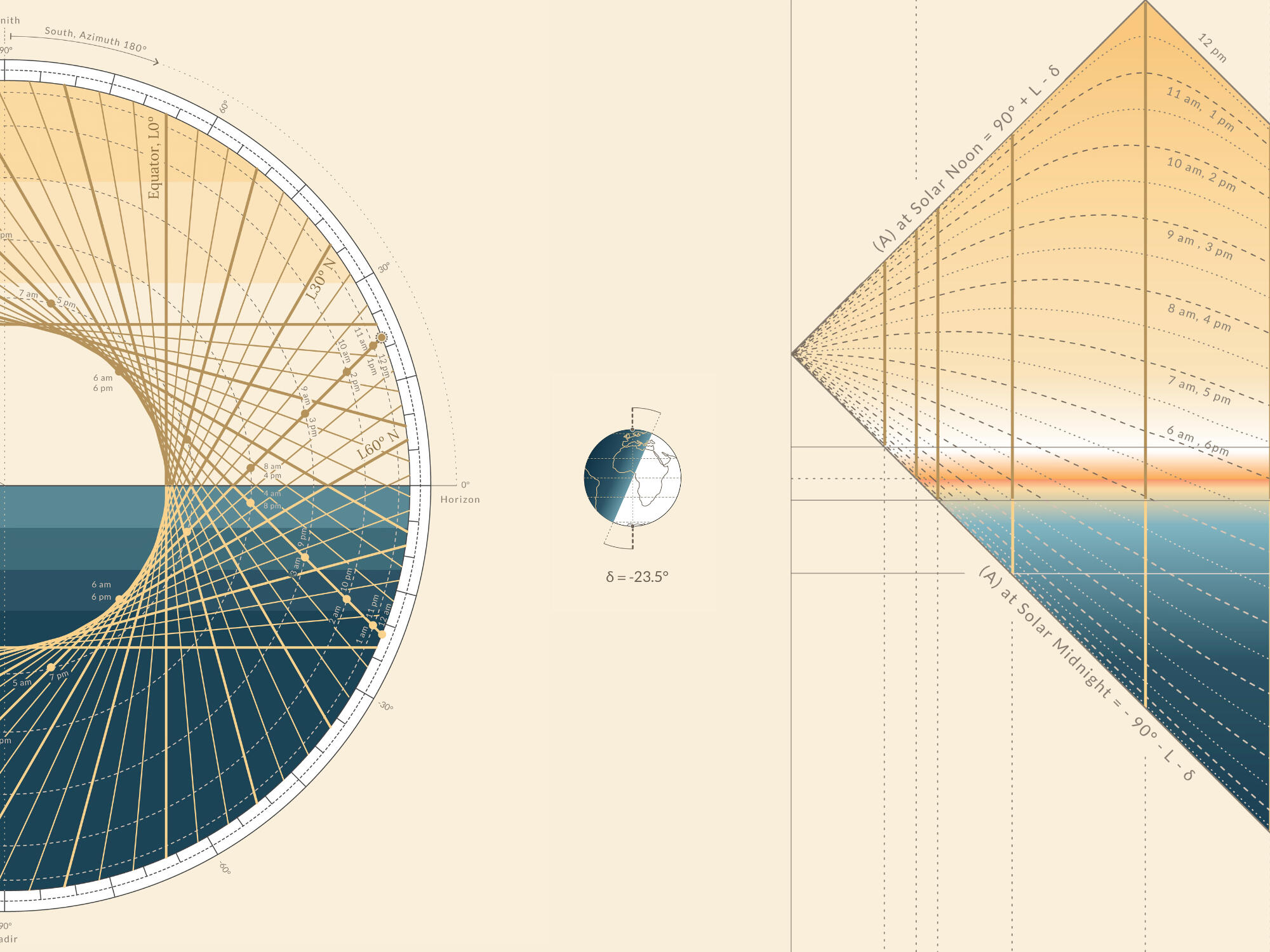
The Omnihorizon Diagram
Sun Paths Across Earth is an innovative series of diagrams that overlay the sun’s daily paths from all latitudes in a single view, revealing how sun paths change orientation across the planet.Diagrams for the Equinox and Solstices show how shifts in solar declination move sun paths north or south, altering solar height, daylight length, and producing opposite seasons across the equator.Drawn with architectural precision, these diagrams sit at the intersection of astronomy, solar geometry, and Earth science —revealing a pattern that governs all life on Earth, rendered visible for the first time in a single image.
Explore the diagram as a finely detailed archival print.
02. Daylight Variation Across Earth
The AltLat Diagram
Daylight Variation Across Earth is a series of solar geometry diagrams that map the Sun’s hourly altitude at every latitude for a specific day—translating complex astronomical data into a single, readable image.Each diagram reveals how, within the same day, the hours of daylight, golden hour, twilight, and darkness shift across latitudes—highlighting the dramatic differences in how sunlight is experienced across the planet.By showing which regions experience the longest golden hour and twilight, the diagrams also offer valuable insight for photographers and anyone seeking the perfect light.
Explore the diagram as a finely detailed archival print.
About
AltZero Studio

AltZero Studio is run by Marta Bueno Martin, an architect with a deep curiosity for geometry, patterns, and spatial systems, exploring how complex data can be translated into clear visual forms.
Solar Geometry Diagrams
The solar geometry diagrams began as a research-driven design challenge: to capture the sun’s behavior across the entire Earth in a single, readable image.In architecture, traditional sun path diagrams describe solar movement at a single latitude, making it difficult to understand global daylight patterns at a glance. This limitation led to the development of the OmniHorizon—a diagram that unifies sun paths from every latitude into one visual system, forming the foundation of the Sun Paths Across Earth series.This exploration evolved into the AltLat diagrams, mapping solar altitude across all latitudes to reveal how daylight, twilight, and darkness vary across the planet.By translating complex solar data into clear visual form, these works combine astronomy, geometry, and design—revealing both the logic and the beauty of the sun’s movement across Earth.
The Prints
Available as museum-quality archival prints on sustainably sourced fine art paper, each diagram is reproduced with exceptional clarity, preserving the fine detail of every sun path, latitude line, and daylight gradient.
Sun Paths Across Earth

The Equinox | Top View

The Equinox | Side View
The June Solstice
The December Solstice


